Cyclone Murasu intensifies over Bay of Bengal; IMD forecasts landfall between Nellore and Narsapur
Cyclonic Storm Murasu is moving towards the Andhra Pradesh coast and is expected to intensify into a severe cyclonic storm by Monday morning, the India Meteorological Department (IMD) has warned.
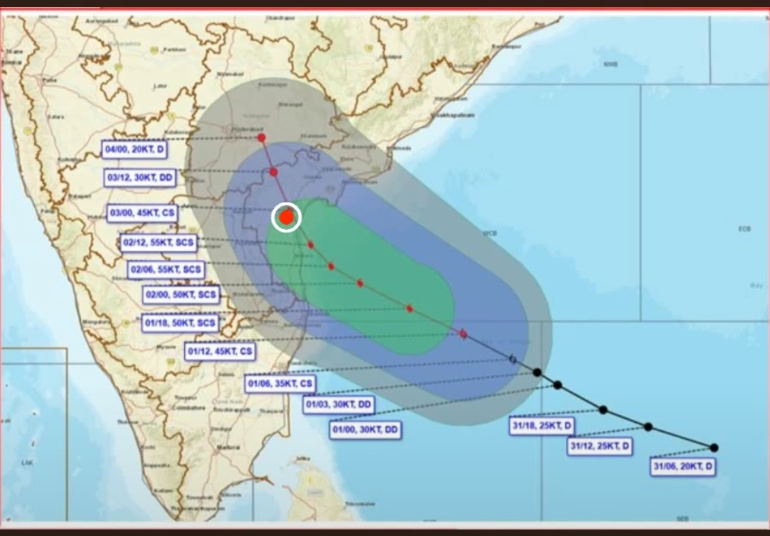
In its latest coastal weather bulletin issued at 9.15 pm on Sunday, the IMD said the storm was centred over the southwest and adjoining west-central Bay of Bengal near latitude 12.4°N and longitude 84.6°E. It had moved west-northwestwards at around 27 kmph during the preceding six hours.
The storm was approximately 480 km east-southeast of Chennai, 550 km east-southeast of Nellore, 560 km southeast of Machilipatnam and 600 km southeast of Ongole.
The IMD forecasts that Murasu will intensify into a severe cyclonic storm over the west-central Bay of Bengal around the morning of November 2 before moving northwestwards towards the Andhra Pradesh coast.
The cyclone is very likely to cross the south Andhra Pradesh coast as a severe cyclonic storm between Nellore and Narsapur, close to Ongole, between 11.30 pm on November 2 and 4 am on November 3.
Wind speeds at landfall are expected to reach 100–110 kmph, with gusts of up to 120 kmph. The IMD has issued a cyclone warning for Andhra Pradesh and adjoining north Tamil Nadu coasts. Coastal conditions are expected to deteriorate, with rough seas and squally weather.
The forecast track and landfall details may change as the system evolves. Residents in vulnerable coastal areas have been advised to follow official weather bulletins and instructions issued by district administrations and disaster management authorities.
The IMD's latest bulletin places the storm about 600 km southeast of Ongole—not 530 km as mentioned in the supplied update. The landfall forecast is for the wider Nellore–Narsapur stretch, close to Ongole; it does not confirm Ongole as the precise landfall point.
More from Andhra Pradesh

Shree Cement unveils ₹7,000 crore investment plans for three cement plants in Andhra Pradesh

AP plans ₹25,000 crore space manufacturing ecosystem, secures major investments in rocket technology

Manchu Manoj named Andhra Yuva Sankalp 2K26 Ambassador; initiative reaches all 28 AP districts
More from Environment

NHAI begins survey for 43-km elevated corridor to Srisailam; night travel could become possible

Cyberabad Police plan one-way traffic loop to ease congestion in Hyderabad’s IT corridor near IKEA junction