ISRO satellite images capture Cyclone Arnab intensifying over Bay of Bengal; Andhra Pradesh coast on alert
Satellite observations have captured Cyclone Arnab intensifying over the Bay of Bengal as it moves towards the Andhra Pradesh coast, prompting heightened preparedness in coastal districts ahead of its expected landfall on October 28.
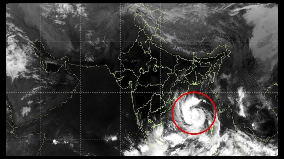
The satellite images show tightly wound cloud bands and a distinct central circulation, indicating an organised storm system. The India Meteorological Department (IMD) said the cyclone was strengthening and could intensify further before reaching the coast.
According to the IMD's forecast issued on October 26, Cyclone Arnab is expected to strengthen into a severe cyclonic storm and could intensify further into a very severe cyclonic storm by October 27.
The system is forecast to cross the Andhra Pradesh and Yanam coasts between Bapatla and Visakhapatnam, near Yanam, by the forenoon of October 28.
At landfall, maximum sustained wind speeds are forecast to reach 115–125 kmph, with gusts of up to 140 kmph. The projected track and intensity remain subject to updates as the cyclone approaches the coast.
The cyclone could bring heavy to extremely heavy rainfall to northern and central coastal districts of Andhra Pradesh, along with southern parts of Odisha. Strong winds could damage power lines, trees, temporary structures and coastal infrastructure, while rough seas pose risks to fishing and maritime activities.
Andhra Pradesh authorities have identified around 5.7 lakh people as potentially vulnerable and are preparing evacuation and emergency-response measures. Fishermen have been advised to return to shore, while officials are preparing for possible power disruptions and other weather-related emergencies.
Residents in vulnerable coastal and low-lying areas are urged to follow official IMD bulletins and local administration instructions. The coming days will be crucial as the cyclone moves closer to the eastern coastline.
More from Andhra Pradesh

Shree Cement unveils ₹7,000 crore investment plans for three cement plants in Andhra Pradesh

AP plans ₹25,000 crore space manufacturing ecosystem, secures major investments in rocket technology

Manchu Manoj named Andhra Yuva Sankalp 2K26 Ambassador; initiative reaches all 28 AP districts
More from Environment

NHAI begins survey for 43-km elevated corridor to Srisailam; night travel could become possible

Cyberabad Police plan one-way traffic loop to ease congestion in Hyderabad’s IT corridor near IKEA junction